Category: Uncategorized
Laredo, TX
Dec 17, 2017
We’ve been traveling south along the Rio Grande River- the US/Mexico Border through “brush country” and oil fields with a few tiny towns scattered amongst a couple of small cities, until we got to Laredo- 400,000 people- 95% Hispanic/Latino and almost as many across the river in Nuevo Laredo. Laredo is the third biggest border crossing- 35-40% of all US exports into Mexico and Mexican exports into the US travel through Laredo!! The State Park we are at is wedged between the city, the airport and the open country.
We stopped in Del Rio at Amistad International Rec Area- the resevoir cut a road off- look closely at the right hand pick! Rhylee is standing in the water on the road on our side.


and Carrizo Springs. Very friendly people every place we shopped.
The weather has been cool, damp, showery and overcast for several days now- not the norm. The rain here makes the dirt thick heavy mud- the roads were super messy on the highway from the trucks coming out of the oil fields, yet we probably got less than 1/4 inch in 24 hours.
Living on the Road…
December 14, 2017
Some of you have asked questions about what living on the road is like and how we manage certain aspects of every day living. Here goes an explanation-
How is this lifestyle different? First, we are not “on vacation”, we are living this way, every day, with many of the “gotta do’s” that we had before. Somethings are easier, some are harder. Somethings are more complicated, some are less. For sure, the difficulties and disadvantages do NOT outweigh the advantages of living on the road.
Some things are constantly changing- finding a new grocery store every time we shop, even Walmarts are laid out differently and carry different items, finding a new gas station every 350 miles and we need diesel- no just popping over to your favorite local grocery or gas station. Hunting down propane refill stations and places to get our hair cut and Rhylee groomed, and laundromats. We have phone apps, gps and internet, however occassionally those just don’t help us, or we don’t have service. We meet lots of new people, and find new foods and options. Most of the time these things are no big deal, but every now and again…
Mail- our mail goes to Livingston, Texas to Escapees Rv Club and we get an email when we have mail. On line, we then choose to have items deleted or have sent- we find a UPS store near where we are going to be for 3-4 days and have our mail sent. We get very little mail!! YAY! Less than 10 pieces a month.
Where are we parking each night?- we use about 5 different websites and apps to find the next location. When there is a holiday or long weekend, we need to make reservations in advance, which means thinking about where we want to be. We avoid RV parks unless we really need to be near somewhere specific- like a Camping World to have work done or buy something specific for the trailer. We look for BLM and Forest Service land mostly, then state and national parks, and sometimes it is a picnic area (if that state allows overnighting), or a Walmart or truck stop parking lot. Sometimes we want or need water and electric hookups for a few days, and some state parks have hookups; we can be off grid for 6-7 days. And then we have to find RV dump stations- got an app for that too!
We’re not on vacation. We still have to pay bills, keep the cupboards and fuel tanks full- just like the many “gottas” we had when we lived in a house attached to the ground. However, the adventure, joy and fun we have every day seeing new sights, exploring new areas and living very simply are well worth the “complications” of being on the road- and of course lots of laughs as we live and learn 🙂
We don’t miss the snow….yet (and we have been in snow three times already). We are getting weary of the dust in the southwest, but it beats shoveling snow. We have seen enough High Desert, but every few hours the details of the desert change- slightly different plants, rocks, colors. We love wearing shorts most every day. We love the incredible quiet and dark skies we see many nights.
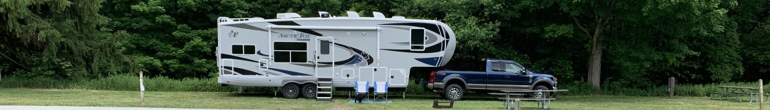
This new trailer has made living on the road tons easier than our beloved Eagle Cap truck camper- just enough more space and storage to make life comfortable, and double the fresh water, black and grey tanks. Our solar panels and lithium batteries generally keep everything running- including the coffee maker and Magic Bullet!
The BIG Bend
Dec 2-9, 2017
It is really BIG! Uncomprehendingly big, bigger than the state of Rhode Island. BUT, there is almost nothing here as far as civilization. The nearest town…tiny town, is more than 40 miles away, the next one is over 80 miles! There is camping and lodging for about 600 people in the National Park. Ya gotta want to be here, to be here! Why?


Well, it is a desert with incredible diversity of plants and birds, mountains that include a “basin” at 5000 ft where there is water and trees, and the Rio Grande River which is very long, but small- 20-100 ft across for much of it.


We had planned a half day float trip in the Rio Grande, but high winds kept us from that. One day we hiked in Chisos Basin – had to be with those trees.


And then a 1/4 inch of rain forecast turned into a winter storm of wind, rain and snow! Texans were a little freaked out, but we realized how special this was- chatted with a Park Ranger about the snow- it usually snows 2-3 times per winter, but not in December and not this much- elevations over 3000 ft had 1-2″ of snow, over 5000ft had 6-9″.


When we left the next day, all the higher elevations were snow covered. AND this storm stretched in all directions- Houston and Corpus Christi even got measurable snow!
Carlsbad Caverns, NM
end of Nov.
Carlsbad Caverns- another place where “there are no adequate words”…or pictures. We walked down into the Caverns two days- 1.2miles down 800 ft. and then into the Cavern rooms- one day a ranger-led tour of King’s Palace and the other day self-guided through the Big Room- which would hold US Capitol Buildings!


Then on to Guadalupe Mountains National Park in northwest Texas- a quiet little park on the side of the mountain. It’s biggest claim to fame is the remnants of a stagecoach stop along a route from St. Louis to California- they could get the mail there in 22 days, guaranteed!
Lave Beds, Mesas and Sand Dunes
November 20-25,
The landscape never ceases to amaze us! We drove along lava beds for about 30 miles today- the lava on one side of the road and sandstone mesas on the other- “The Narrows”. Stopped at another free campground on the top of the mesa!
Albuquerque- Enchanted Trails RV Park- nice “retro/Rt 66” place but right on the interstate! Camping World is right next door and we had on order a reclining love seat. We do try to avoid cities, especially large metro areas, but sometimes we just gotta be there. We figured out months ago that any city with more than one Walmart Supercenter was going to be way to big for us, but what ya gonna do? Lots of errands to run- Mail had been shipped to a local UPS store for us- our new South Dakota trailer plate! We both needed new hiking shoes- (no LL Bean out here) Cabelas and REI, Home Depot and Walmart of course and then our new favorite bread store- Great Harvest- all the way across town, about 10 miles of stop and go, traffic lights and bumper to bumper, lunch in Old Town- really great southwest/Mexican food, and a chocolate shop for us and chocolate espresso beans to send to Derek. We did hike to three volcanoes, too and went to a city owned huge shooting range for a little target practice.


We also met some RVers with a trailer like ours- Outdoors RV- not many around as they are meant for off road. AND we met an older couple from Van Buren, Maine trailing a “tiny house” they had built! We have only met a few Mainers on the road and seen less than 6 ME license plates.
There is less federal open land in this area so finding dispersed camping sites and even state parks is a little tougher and most RV parks seem to be right on the interstate! San Lorenzo Canyon- the deepest we have been off the beaten path- 5 miles of dry river bed sandy “road” into a canyon- quiet and dark!


Getting in and out of the road to the canyon was also interesting:


Sandhill Cranes, which we saw in Colorado at Great Sands, are now migrating through here and we have seen several very large flocks. Water is at a premuim here- it is giving us another level of appreciation for our water and water back home- all animals cluster near any pooled water, even through the Rio Grande runs here, most of the creeks running into it are dry and have been for months.
White Sands Area- more lava and desert


, but warm- in the 70s. We went sledding in the sand dunes, which are gypsum, not sand, not silica.


It was a blast! We met a family from Houston (but from Venezuala before that) and we let them use our sled- lots of laughs and fun- Rhylee, too- check out his diary entry.
Our Campground is a the beginning of Dog Canyon, with a creek that actually has water in it this time of the year- a bit of an oasis here.


And some history- “Frenchy” lived here in the 1880s, built rock walls up the side of the canyon, made cement irrigation down the canyon so he could grow fruit trees, and built it 1.5 miles long to irrigate a neighbor’s ranch.  Also indigenous peoples from way, way back lived here- mortar holes for grinding grain-
Arizona…wants me
November 9-13, 2017
Anyone remember that song?
Our solar panel system stopped charging last week and so we are at Camping World. Clare and the Zamp technician did some troubleshooting and narrowed it down, and so we are here resolving the issue. Our solar panel system on this camper is 50% than on the Eagle Cap and with the Lithium batteries we should be good on just 6 hours of sunlight a day, but…so Clare is running down every last little possibility to maximize our power!
We’re near Flagstaff heading towards Sedona and then across Arizona to Albuquerque, NM to another Camping World to have our couch swapped out for a reclining loveseat (we will be living large!). Then towards Padre Island, Texas.
Peepers, trees with leaves and 70 degrees! Say what? yup, we are in Cape Verde, AZ and the scenery and weather have changed, surprisingly. As we drove through the canyon north of Sedona we saw big tall trees with leaves on them!


WOW! haven’t seen that since mid-September. Red Rock Sedona was drier, but apparently has irrigation water as we saw businesses and houses with flowering shrubs and tall decidious trees. Stopped at an RV park on a flowing river with 200 year old Sycamore trees with their leaves still green! And then the peepers started in at dusk…very sweet!
Petroglyphs! Yup- in a little state park on a small lake that is part of the Little Colorado River, along the shore is a small rocky hillside with petroglyphs scattered among the rocks- they are about 1000 years old!


And in November, although the weather is in the 70s there are only about 5 campsites occupied, and we are right on the lake!
Grand Canyon
November 2-9, 2017
What can we say? There are no words to describe the expansiveness of this place! It is quieter here this time of year, however bus after bus rolls in with travelers from the US and the world for their 4 hours of the Grand Canyon- selfies as quick as the phone will take them, people posing on the edge, and then rushing off to the next view point. Fortunately, we are finding the quiet spots and spending time really looking at the canyon.


The geology of the place is fascinating and we went to a Ranger talk about it which created more questions- we ran into him along a trail and walked for awhile with him asking him our questions and he was happy to oblige us.
The weather is around 60 daytime and 40 nighttime, but very windy.


The Canyon has a great shuttle bus system to get you around the 20+ miles of rim, but not enough parking… So we drive, park, walk, shuttle, walk….to get to where we want to be- we can’t imagine what it is like in the peak months! Walking along the eastern rim we discovered Orphan Mine- long story short- it was a copper mine way back and way done over the rim edge, then in the 1950s high grade uranium was found here and mined for several years (yup on NPS land, but the mining rights were old and sold). Now they have a contaminated area, that has been mostly cleaned up and fenced off- of course we found this all fascinating and most people totally missed it!
We took an airplane tour of the Grand Canyon- Clare is a pilot and we have tried to arrange this a few other times this summer- here they have about a dozen planes and helicopters that give tours. Our plane was a 9 passenger Cessna Caravan. They are not allowed to fly right over the part of the Grand Canyon that grounded tourists use, so we flew east and then north, crossing the canyon beyond where the Little Colorado joins the Colorado River, then across the Kaibab forest north of the North Rim flying west until we were beyond Hermit’s Rest and crossing the canyon again.


We were able to see long stretches of the Colorado River, which you can not do from the Rims. The views were amazing, such a different perspective of the Grand Canyon. Oh, did I mention? It was very windy 25 knots and gusty, so we had turbulence, which bothered me quite a bit, but I managed to keep my lunch down and still enjoy the views.
We hiked a short trail down into the canyon about 600ft. drop in elevation in .9 mile. It was all switchbacks and awesome views. We stopped at Ooh Ahh Point and headed back up.


It was nice to see that we did not struggle on the way up, as many did- many who should not have started down! We chatted with several young adults that were doing conservation corp work at the bottom of the canyon- 9 days down and 5 days off in Flagstaff. They hiked up from the bottom in less than 4 hours- about 9 miles and over 5000ft up!!
Four Corners
October 31, 2017
One just can’t go by this part of the west without stopping at Four Corners- and so, here we are…


As usual, Rhylee was not allowed inside near the mark, but he did walk through all four states…(check out his page!)
One night at Navajo NPS- free all year! Walked to another cliff dwelling and learned more about the plant life in this area.


Pine Nuts come from Pinon Trees and this is harvest time. We saw people collecting, buying and selling. Apparently it takes two years for a pine cone to mature the pine nuts, then they are harvested by hand off the tree, dried, then separated from the cone and then hulled and roasted. IF we had been on Forest Service Land or BLM land, we could have picked up to 25lbs of pine nuts without a permit, but we were on National Park and Navajo land.
Mesa Verde National Park
October 24-30,2017
Another unsung hero, so to speak. We are camped on BLM land facing the Mesa- this is rough terrain, 12 campsites spread over 2-3 miles.
This is a really cool National Park! Pueblo cliff dwellings- which came after pit houses and Pueblo houses on the Mesa (which is actually a cuesta- a mesa with a slope). We actually took a walking tour (climbing actually) of Balcony House- down 3 stories of stairs, up 30ft on a stick ladder, through a 12ft long 18inch wide tunnel, up to 15ft stick ladders, and stairs cut into the rock.


ALL of this was on the edge of the cliff, hundreds of feet above the bottom of the canyon!


The cliff dwelling ruins were amazing- about 70% original! Oh, did I mention we were at 7000ft elevation? The Puebloans lived here from 550ad to 1250 ad when they all just left over about 30 years. Was it the 23 year drought? Tribal conflicts? It is a mystery, however, it is known that they moved south and formed new Pueblo villages.


On a side note- our new camper is working out really well! We can’t always find everything, especially if we decide to move it to a “better” spot in the camper Because the trailer is “off road” (heavy chassis and suspension) we are able to go on rougher roads than we could with the truck camper. And we are drawing attention- yesterday while at Walmart, a big older motorhome pulled in beside us and they wanted to admire and chat about our rig!
We’ve moved to McPhee Resevoir campground- Forest Service, semi-closed for the season, so no services, but only 5 bucks a night. 3-4 other campers in 60 sites! This resevoir was made in the 1980s – they moved out the few people here and some houses, it had been a lumber mill town back in the day with logs being brought in from the east by rail.


We’re waiting for Clare’s long overdue laptop to be returned by Dell and FEDEX- long story of misery for this saga that we will spare you 🙂
40-60,000 Ancient Puebloans (or Anasazi) lived in the four corners areas around 900- 1200ad, so there are tons of archealogical sites to visit. We have confirmed that different federal agencies do not always support each other ( no surprise there, right?) Mesa Verde National Park only barely shares info about the other local Puebloan sites and the BLM (bureau of land management) barely shares info about Mesa Verde…makes it a little tricky to figure where to visit in the thousands of acres with sites. We have had to ask detailed questions of visitor center staff to get deeper info.
Did a 4 mile hike into Sand Canyon, elevation 5400-5900ft. Viewed 3 small Anasazi sites, as we hiked up into the canyon- these pics show the very delineated layers of “geological history” of these mesas.


We are pretty well aclimated to the elevation; especially when we see how other hikers our age struggle 🙂 And Rhylee just plugs along so long as food and water are available!


RAIN! It rained last night! We can’t even remember the last time we had rain ( we had snow three weeks ago in the CO mountains), perhaps it was in Idaho in August…? It was only a few hours of showers, but it was rain. And it brought out even more mule deer than the 3-4 we’ve been seeing every day- 22 at one point.
Great Sand Dunes
October 19, 2017
And they are GREAT! We camped in a defunct state park that is now run as a wildlife refuge. It is kind of like a ghost campground- 51 sites, fire rings picnic shelters, pit toilets but NO management! And the electric was still on and it was FREE! We had views of the mountain range 50 miles to the west and more 10 miles to the east with the Sand Dunes at their feet.
The sand dunes were formed over the last 450,000 years (not too old in the scheme of this planet) by prevailing winds blowing sand from the west across the valley to the base of the mountain range, and other winds eroding sand off the tops of those mountains. The tallest are about 700ft high, the spread is about 10 by 20 miles! You can hike, sand sled and sandboard them! It is tough walking, just like dunes at the beach! And the elevation was over 7000ft.


We headed back into the mountains- passing farm land and then into forested land- we realize every time we get back into the trees how much we really miss them! Here it is pine and Colorado Blue Spruce-
 naturally growing ( I paid big bucks for one at my Hope house!) – whole mountain sides of them! We’re camping on Forest Service land tonight, alongside the Pass Creek, on a dirt road, only a couple others within 2-3 miles- free again! FS land for the next night- full of hunters – they did lots of driving around, but not much shooting…Did you know, that only 11 states ban hunting on Sunday? yup!


