Category: Uncategorized
Alaska Marine Highway
Sept. 14-24, 2018
The drive from Fairbanks to Haines was another incredibly scenic drive- 640 miles. A couple of lovely campgrounds on large lakes. Mountains, glaciers, forests, taiga and very few vehicles.
Haines is where we got the ferry- the Alaska Marine Highway is a ferry system that has been designated a Scenic Byway! Many cruise ships go the same route and stop at many of the same ports that we are doing on the ferry. We have five stops: Juneau, Petersburg, Wrangell, Ketchikan and Prince Rupert. Because Rhylee must stay in the camper on the auto deck we have opted to get off for a few days at each port and not go beyond Prince Rupert because that leg is over a day long.


Haines- the sockeye salmon are running here, but slowly.


We saw a bear catching them in the river for her two cubs, but no people even fishing- so we went to Haines Fish Packing and bought fresh sockeye! The sow had an ear tag and radio collar, the cubs had ear tags.

Notice baby bear swimming towards Mama…the river pushed it quite a bit downstream.

Juneau- coho are running here and we fished to no avail, but the weather was sunny and warm and the locals at the dock were very friendly and chatty- they weren’t catching many either. On the dock you had to “fish” and just a 100 ft. away you could “snag” – meaning you could jerk you hook through the water and snag a fish any place on it’s body- even those folks weren’t hauling in too many. AND we could see them in the water- lots of them!  We visited another Glacier- Mendenhall and saw bighorn sheep on the mountain.
Petersburg- got on the ferry at 5pm, got off at 2am…Parked at the ferry terminal and slept a bit and then found our campground. Beautiful island, with a small fishing town of 3,000 people.


Wrangell- morning trip through the 20 mile Wrangell Narrows-

Yes, our 400ft. long ship navigated through these “pinball machine” markers.
an amazing narrow and twisty passage with over 70 aides for navigation. The ferry had to wait for the tide to come into port and we went down the narrows at half tide. 
Wrangell is another lovely small town with friendly people. Most of the boat tour operators were done for the season, however we found one that had to make a run up the Stikine River


to deliver some pipe to a summer house and was willing to take us along and show us some sights. 2+ hours on the river which was exceedingly low and shallow and watching Eric pick his away along was fun.


Petroglyphs…mostly covered at high tide, and historically unclear as to who, why and what they mean.
Side note- taking the ferry is awesome, however it is stressful…for us 🙂 we have to be at the ferry 2 hours before departure, get our boarding passes, and then wait, then turn off the propane, and load onto the ferry- sometimes backing down the ramp!, settle the dog in the camper, hook up the inverter to run the fridge. These ferry boats are big-400ft long, 7 decks. The departure times are all over the place and the length of trip are all different, sometimes arriving in the middle of the night, or the early morning. We are not used to “pressure” or reservations, or someone else’s timeline! LOL
Ketchikan- when we booked the ferry back in April our choices were 4 days here, or 7. We chose the 4. The RV park we are at is actually a Salmon Fish Camp with boat rentals, fish processing, dinning room, RV sites and hotel rooms and is connected to two other fish camps that land their fish here. Our first walk down to the dock let us see five bins full of Coho Salmon! The limit is 6 salmon per day per person and these anglers were trying to max their catch to have the fish processed and frozen to take home- some of them take home over 300lbs of salmon!
The weather has been sunny and in the 50s for the past 2 weeks, and so on the chance that the weather would hold we reserved a boat for the next day. They set us up with gear, bait and information as to where to go to fish- 25 miles up Clover Passage and Behm Canal. Within minutes of getting both rods set out- one used a down rigger which took a learning curve to figure out- we had two Cohos on! We landed one and lost the other.


And then we trolled for the next several hours without a bite. Of the 20 or so boats in the area, we only saw one fish caught every half hour or so…It was just lovely to be out on the ocean on a sunny, calm day- this island area is reminiscent of Penobscot Bay however 95% of it is protected temperate rain forest and their are mountains all around! 
Finally, Prince Rupert at 8pm but we still have to get off the ferry and through the border crossing and then to the campground…in the dark.
Fairbanks and Chena Hot Springs
Early Sept., 2018
Played tourists while in Fairbanks- took a trip on the Paddlewheel Riverboat Discovery down the Chena River to the confluence with the Tanana River. Tour buses are still coming in and so the boat which holds 700 people had about 400 cruise tour people and just a few of the rest of us, but the boat is big and there was plenty of room- 4 decks, most enclosed.  The paddlewheeler is owned and operated by the 4th generation of the same family that came to Fairbanks for the goldrush- to move cargo on the river- in 1898. In the 50s the next generation started the tourist trip side of things. We learned so much about the area, Fairbanks, the Athabascan natives (many of the crew have Athabascan heritage).
They have re-created, with some original buildings they moved, a native village and crew lead tours through it. They have a small reindeer herd – related to caribor, but not the same- reindeer are considered domesticated and can be kept, while caribou may not be.
This native parka has been


appraised at $26,000! We had wondered about the bead work we have seen in Athabascan crafts- where did they get glass beads? Well, they traded pelts for them with westerners.
Catching and smoking salmon, of course, was a big part of native life. Fish camps, weirs and smokehouses were built along the river.


King and silver salmon were dried for human consumption, and pink salmon were dried for the dog sled teams.
David Munson, a famous Iditarod racer,  spent time telling us about his dogs, his more famous wife Susan Butcher- won the Iditarod 4 times- with her famous dog Granite, and gave us a demonstration of mushing.
And a float plane landed and took off a few times right beside the paddlewheeler and talked to us through the two way radio.
A fun and worthwhile excursion, for sure!
We went to a salmon bake one night and then to a “Revue” at Pioneer Park- a collection of old buildings moved here from around Fairbanks from the turn of the century. The play was staged as from the olden days, and told stories of the past with songs and humor. Lots of fun!
WIth the prospect of a few sunnier days we headed up the Chena Hot Springs Road to, hopefully, do some fishing, hiking and go to the hot springs- TWO clear days in a row!! The Hot Springs were nice, but not as nice as others we have been to. And we fished and caught Arctic Grayling – Clare caught them here in Alaska in 1965 and so was thrilled to be able to catch them again. We were at 48 mile pond, it was warm and sunny and the fish were jumping. One dry fly that we had worked and we were able to land 7, enough for dinner, as these guys are rather small. A lovely day that provided us with a yummy dinner.
I got up both clear nights to look for the Northern Lights, but to no avail.
Cold nights are here, below freezing, time to held south to meet the ferry in Haines, AK.
Dalton Highway, aka The Haul Road
(intermittent internet service is postponing our posts to the blog 🙂
August 28-Sept. 2
This road was built for one purpose only- the Trans- Aleyska Pipeline. Oil was discovered in Prudhoe Bay in 1968- remember the oil crisis back then? A consortium of oil companies working with the federal and state governments planned and built a 438 mile road and a 800+ mile pipeline to bring oil from Prudhoe Bay to Valdez to be shipped out.


The road was built in FIVE months. The pipeline took only took 3 years, finished in 1974.


Back to the road-from Livengood to Deadhorse it is for trucking, and it was not open to the public until the 80s, and then only to Coldfoot, and in the 90s opened all the way to Deadhorse. The trucks have the right of was- always.


The posted speed limit is 50mph. The road is gravel, pavement, tar and gravel, and every combination of those. It was great in some areas- 50mph with the camper in, in others 20mph was a stretch. Services are VERY limited on this road- fuel in three places over 438 miles (with the possibility of NO low sulpher fuel at Deadhorse), two “camps” with a cafe, workcamp lodging and fuel, 3 BLM campgrounds, no repair services. Deadhorse is an oil camp with a couple of workcamp hotels. And you can NOT get to the Artic Ocean (the reason most people drive those last 200 miles) without taking a tourist excursion 8 miles beyond the Oil Camp. We have heard- you MUST do it, or it is pointless to go that far….we did not.
So, why drive it? It is the easiest way to drive to the Artic Circle- mile 115 on the Dalton Highway.  And above that? well, it is only what becomes you in this truly desolate remote area of Alaska. We decided to take the camper as far as Coldfoot, and then drive just the truck up through Atigan Pass as far as the beginning of the North Slope and the artic tundra.
The views are spectacular, the road too, but in a very different way. Fortunately, this late in the season there were fewer private vehicles and rvs out here, and autumn has started here, so the colors are beautiful.


We had wet weather the first two days driving- the camper and truck were covered with mud- on some places 3 inches thick!


The day we drove in just the truck further north was rainy and then….snowy…and cold…we went down to 26 degrees! and the day never got over 35- 26 degress at the Pass at noon time! From before Atigun Pass through the next 45 miles everything was white- we saw the Arctic Tundra,


but it was white- several inches of snow had fallen overnight and flurries chased us all day. Too cold and wet to hike.


And then it cleared, back at Marion Campground, mile 160, it was sunny but cold, which meant possible Northern Light Viewing. So, I got up at 1:30am and there they were! Not very colorful, but vivid and in motion across a large area of the sky.
Headed back out, knowing it was a long bumpy drive we planned to stop and hike a couple of times. Once at South Koyukuk River- supposed to be good gold panning here, but it was TOO cold, although we did see a couple of air boats come in from down river. Finger Mtn was a great rest area-


an interpretive walk describes the plant, animal and geologic life here. These boulders are big versions of the frost heaves in Maine roads in the spring!


We hiked across lots of these rocks on a trail that really wasn’t a trail out to Finger Rock- this rocks points towards Fairbanks!
Mythbuster – Alaska is NOT teeming with wildlife- yes we saw a lot in Denali NP, but we have seen very little elsewhere in the state. Alaska has massive areas of preserved land- most of the land north of Fairbanks. In our 20 hours, 600 miles of the Dalton Highway we saw- 2 mooose (twice, 4 hours later they were still in the same pond feeding), 2 ptarmigan, a ground squirrel an eagle, ravens and an Silver Fox- which is very rare.


This land is so sparse in vegetation that animals need a lot of acreage to survive here.
More Alaska- The Denali Highway
August 21-
The Denali Highway- did I mention that all “highways” (that would be any road that goes more than 20 miles 🙂 have names and route numbers, however no one ever uses the route number! The Denali Highway goes across south central Alaska- and it is gravel- some of it very rough gravel. It is probably the most scenic drive in all of Alaska – spacious views across taiga, foothills, river valleys to mountains and glaciers. We happened across it during Caribou hunting season, so the whole road was crawling with campers, trucks, atvs and hunters!


This road is a geological goldmine! We parked on the side of the road one night on the top of an esker- a long ridge of sand, gravel and stone created by a river underneath the glacier thousands of years ago. This one was a couple miles long and gently curvy. We had great views of the entire valley 15 miles to the mountains on either side. There was a gold mining area along this road until the 1990s. We also went by kettle ponds- formed when chunks of glacier settled and melted. And this new one for us- palsas- 20ft high dome-like mounds formed by frost, full of peat.


So, have I mentioned the weather here lately? Well, it is…let me be nice…it is cloudy, showery, overcast, and rainy most of the time. In the last 12 days we have had one day of sun and just a few glimpses of the sun every now and again. The locals are telling us this is the wettest summer they have seen in a long time…great 😦 This weather is very much like what we experienced in Texas on the Gulf Coast last winter- ugh! In the six weeks we have been in Alaska, we have maybe had 6 sunny days! Much of this wet weather comes from the west and the south- from the ocean. We are heading north tomorrow towards Fairbanks- hoping for sunnier days. All the wet has been beneficial for some things:


Birch Lake State Park- pretty little lake, the weather cleared, hardly anyone here. We met a military chopper pilot that told us what he liked about the Dalton Highway- Atigun Pass. As night came on, I was hopeful that the skies would stay clear so we could see the Northern Lights- this is the low end of the 10-12 year cycle of solar flares. I follow an Alaska University website that predicts the Lights and tonight is a possible. So I set my alarm for 1am and got up. YAY! I watched for about 2 hours and did see the Northern Lights, from right inside the camper mostly as it was cold outside. No spectacular colors, but distinct patterns in the sky.
 Stopped in Delta Junction the “end” of the Alaska Highway, which we started weeks ago in Dawson Creek, BC
Fairbanks- the campground is within the city limits- between the airport and downtown! Did our errands and got re-stocked to head up the Dalton highway.
Denali by Ground
August 14-19
Denali National Park and Preserve is not a particularly easy park to visit. The Park and Preserve are over 6 million acres, yet there is only one road into the park – about 90 miles long and personal vehicles are only allowed on the first 15 miles. We camped at the entrance area at Riley Creek Campground to prep for 5 days further into the park at Teklanika Campground which is at mile 29- this is the only campground beyond the pavement that allows vehicles and RVs, however once you get to your campsite you may not use your vehicle except to drive back out on the day you leave.
There is a great shuttle bus system for the road. Busses come and go constantly and make frequent stops for wildlife and rest areas.  To go from the park entrance to Kantishna is 92 miles and takes 12 hours round trip! Staying at Tek Campground cut 3 hours off trips further into the park. Even so, since Rhylee had to stay in the camper, we limited ourselves to Eielsen Visitor Center at mile 66- about a 5 hour roundtrip.
Wildlife is awesome here- there is the Big Five and we saw four of them- Grizzly, Caribou,  Moose and


Dall Sheep- we did not see a Wolf- very elusive. Bus drivers know where to look and stop whenever a passenger spots something. We also saw golden eagles, Harrier Hawks, Gyrfalcon, Merlin Falcons, ground squirrels and hoary marmots.


The grizzlie bears here have blonde fur! Apparently, in Denali these bears eat mostly plants and berries, where others eat mostly salmon and this impacts the color of their fur.


One group of a sow and two cubs were intently eating berries on the hillside- one cub though would run up and down the hillside checking out his mom and sibling and looking for the best berries.
 Another day, a very large, healthy male was wandering along a river and decided to lay down in the river to cool off a bit- it was sunny and maybe 55 degrees that day.
We road the bus into the park 3 days of our five at Tek, with the inbetween days hiking the on the gravel bars in the Tek River. Each day we did see wildlife, sometimes closer than others- twice we had fairly close looks at Grizzlies, and once a caribou  decided to run down from the plains to the bus, along the bus, in front of the bus and then down the other side of the bus.
Alpine plants,  including lots of flowers still in bloom, berries- including wild blueberries!- and shrubs and tundra plants were very unique to see and admire.
Of course, the one thing everyone wants to see, but only 30% do see- is Denali Mountain. It can be sunny everywhere around the area, but Denali makes it’s one weather. There are spectacular views in every direction, from every corner on the road, yet it is hard to not be focused on getting a view of “The High One”.


We lucked out on our last trip into the park- an incredibly clear day at the campground that stuck with us all the way to Eielsen Visitor Center- base to summit views which are even more rare than just the top of the mountain.  It is majestic!


We sat and just “communed” with the mountain, while others ran around taking selfies, rushed up a trail, spun through the visitor center and jumped back on their busses…Hardly anyone spent more than a few minutes really looking at the mountain…
Geeks that we are- we learned that Eielsen Visitor Center at mile 66, is powered by the sun and a small hydro-plant in the little creek! Passive solar on the roof- where the roof is not a walkway or a garden and solar panels on the southern roof edges generate half of the power needed. The hydro plant generates the rest. The creek also supplies water, which they filter for the water bottle refill station.


We truly consider ourselves fortunate to have experienced Denali under sunny skies. And we had some great conversations with Park Rangers about their roles here (one works here to study dinosaur fossils), the park and mountain and even met two “artists in residence” who are allowed to drive their vehicle all along the road and camp 50 miles in.
Denali by Air
August 9, 2018
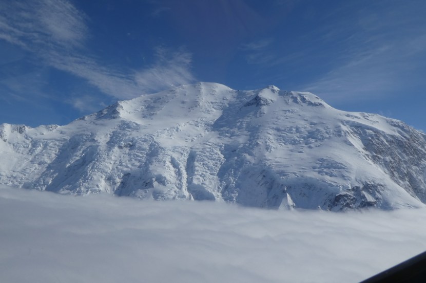
We were fortunate enough to see Denali Mtn. by air and actually SEE Denali. The weather here is cloudy much of the time and the Alaska Range makes it’s own weather which is frequently cloudy. We called at noon with clear skies to fly that afternoon, by 3pm the clouds had started to form around the mountains. Of course, the pilot prepped us for maybe not seeing Denali, getting to the north side or landing on a glacier ( side story- we did not care about doing this, and the company did not have a another flight going up that was not landing, so we got the landing on the glacier for free – $100/person!)
We lucked out- there were clouds, however we flew over them and more than halfway around Denali at 12,000-14,000 ft. Denali is the second tallest mountain in the world just behind Everest.


We landed (and took off 🙂 from a glacier which had recent snowfall. Clare sat in the cockpit on the way out and I did on the way back (there were 8 other passengers). We flew within 1/4 mile of the cliffs and were up almost 2 hours.
Side note- a flight-seeing plane with 4 passengers and pilot crashed last Saturday, killing all on board, although at least some survived the initial crash, as the pilot made two calls out for help. The weather closed in and the plane was precariously perched on the side of Thunder Mtn. On Monday, Park Service people lowered a man from a helicopter and while tied to the chopper got inside the plane and found 4 dead and could not locate the 5th. Very sad for all concerned. The safety record here is long and deep and at this time it has not been determined what happened to cause the crash. The passengers were from Poland and the pilot was from Michigan. Another attempt and they did find the 5th body and have decided that they can not remover the bodies or the plane.
As is often with nature, there are no words to describe what we saw or felt up there. Here are some of the photos- check out our photo gallery tab (give me a week to get them up, as we are heading deeper into Denali and will not have internet for 5 days) for more if you are interested.


Denali is surrounded by glaciers, and other mountains.


This is the glacier that we landed on.


More of Kenai
July 28
All alone at Clam Gulch Campground- 120 campsites (well, packed in like sardines sites) and we were one of two campers here for two nights! with a view of the ocean! Clam digging used to be big here, really big, until they clammed them all out and the flats were shut down, so now hardly anyone uses this campground. We loved it! Used it to do errands and chores in Soldotna and Kenai- finding a pet groomer for Rhylee is always a challenge, however Petco’s have been reliable when we can find one- so Rhylee had his morning at the spa while we got the fuel filters changed on the truck, hit the Walmart and Home Depot, etc.
Anchor Point- the westernmost highway accessible point in the US! 4800 miles from West Quoddy Head, Maine- the easternmost point.
This is where Skidders go to die…. Extreme tides and very shallow flats here- look at how they launch boats here- all day long- 
Homer- perhaps the first “tourist town” we have been to in Alaska. A long, narrow sand spit with RV parks, tourist shops and fishing charters and not much else.
Across the Cook Inlet are mountains and volcanoes and preserved land- only accessible by boat or plane. There are several very prominent high points over there and we watched for clear enough weather to get some pics- St. Augistine, Mt. Illiama, Redoubt Mtn. and Spurs Mtn.- around 10,000 ft. tall.


Doing a bit of fishing – as I mentioned before, the rules are very complex here- flowing water, lake, ocean, salmon vs other species, barbed vs unbarbed hooks, location, etc. etc. And then 5 species of salmon and steelhead trout that all look a lot alike. We watched some fish heading up stream near Captain Cook Rec Area- could they be steelhead? It is a NO salmon fishing area…At high tide we could fish for the salmon from the ocean side of the shore, but not in the river 50 ft away. Watched the sockeye jump in the Swanson Creek, but never onto our hooks- still a lovely day on the shore and not a soul around.
Lots of eagles and seagulls just waiting for a free meal:


Quartz Creek, back at Cooper Landing, starting to head towards Denali. And the sockeye are spawning here now and easily spotted in the river- NO fishing for them here, but so cool to watch…and sad- they live a few years in the ocean, come back to their birthwaters to spawn and then die…turning bright red in the days before they spawn.
Hope, Alaska!
July 23-24, 2018
Just couldn’t pass up the chance to visit another town of Hope.  Hope, Alaska is just a bit off the beaten path on the Kenai Peninsula and the Turnagin Arm- (a salt water basin with a tidal bore). Hope- population about 125 claiming year round residency (but probably not many here in the dead of winter). A couple of campgrounds, restaurants and Salmon fishing where Resurrection Creek enters the ocean. “Combat” fishing as it is known in Alaska- shoulder to shoulder along the water, waders on, in 3 feet of fast moving water. No “snagging” here, single hook that you hope will enter a pink salmon’s mouth…we did not participate for oh so many reasons, however we did talk to a couple of anglers- one from New Jersey that comes up every year to catch salmon, freeze them and take them home and the other a Kenai native who’s family runs a gold mine with mining trips, a fishing charter business and a fish processing business. Local Halibut for dinner at the cafe, where we discovered one of the cook’s was from Peak’s Island, Maine!
Kenai River and Lake- beautiful for sure, however anglers everywhere and guides and outfitters and trips- very busy place! We fished a little here and spent one very foggy day in Seward


– hiked to the foot of the Exit Glacier and then lunch in town- salmon, halibut and rock fish.


Fishing on the Russian River was slow as the sockeye were just starting to arrive- we walked up along the river – formal boardwalks and access stairs all along about 1 mile of the river keep people from trampling the entire area.  No fish for us, but we did spend about 15 minutes watching a 2yo brown bear (aka grizzly) sun it self 100ft across the river!
We’ve met lots of travelers- many from Texas where it has been over 100 degrees! And spending big bucks to catch sockeye and trophy rainbow is what they are here to do!


We fished a little at quiet Cooper Lake- beautiful, we were the only ones there, this laked is stocked with trout and char, but none landed on our hooks.
Valdez, AK
July 12-18
The weather here is a bit wet- it rained here most of last week while we were at Kennecott- the Chugach Mountains kept most of the rain to the south of us, although we did have light showers most afternoons. And Valdez got a couple of good days- some sun and highs in the 50s and now more cold and rain…rather dreary, for sure, but this seems to be the summer weather pattern- I guess preferrable to the 25 FEET of snow they get each winter!
Prince William Sound by boat-
We took a wildlife and glaicer tour on the Lu Lu Belle- fortunately the weather stayed dry and the sun even showed up for part of the trip- the 9 hour trip. The Sound is HUGE and very protected by the Chugarch mountains which include mountainous islands in the sound, so the waters can be very, very calm. We “woke up” a few groups of sleeping sea otters on the way out of the harbor.
The day of our trip was the “opening” day of commercial pink salmon fishing. Over 100 fishing boats were out in sound- each boat had a crew of 4-5 one person in a “skiff” hauling the seine purse net away from the boat to set it and then to help bring it back when the catch was in.


We stayed extremely close to one boat as they brought in their catch and then one of the crew passed plates of brownies to the crew using a dip net!
Lots of wildlife, and many very up close views as our captain was incredibly adept at moving his boat in to tight spots.


And then the Columbia Glacier- he moved us through about 9 miles of icebergs to within 1/4 mile of the face of the 200ft high and a couple mile wide glacier for an up close and personal experience.


And Linda never passes up a chance to steer the boat-


The captain has been doing these tours for 41 years! And lives on the boat around the Seattle area in the off season. He gave an informative, and historical commentary most of the trip, including details about the Exxon Valdez oil spill in the 80s. He has a quiet, wry sense of humor and one had to pay attention to pick up on his personal opinions.
Since the pink salmon have just started to run, we decided to buy licenses and fishing gear and try our hand at salmon fishing. We have another 8 weeks in Alaska so we might catch a few. Clare started by fishing for artic grayling in the lake at the campground- some hits but no fish. And then we went out to Allison Point and the place was hopping- the fish hatchery there gathers spawning Pink Salmon and Chinook to collect eggs and raise salmon fry. The salmon are not ready to spawn quite yet, but are not hungry either. As we watched others fish from the shore, we were quick to figure out that those that were catching fish were “snagging” them, not quite sporting, but the fish aren’t hungry.


So, Linda and Rhylee watched from the top of the bank while Clare cast the first line- it wasn’t long before he had some snags and then pulled one in. The tide was going out and the salmon were moving back down the stream. It took Linda a bit longer to get one- other anglers had moved in closer making casting trickier.


The limit is 6 per day, but we settled for one each- they were about 18 inches long and maybe 3lbs. We gutted them at the shore and iced them down.
We camped on the side of the road that night…in bear country- oh wait most of Alaska is bear country. To finish cleaning them and readying them to eat, we gingerly prepped them away from the camper, with Clare watching for bear with his bear spray ready. And of course, cooking them spread the lovely aroma all over the area. Pink Salmon is lightly colored when cooked and mildly flavored. Looks like we will have salmon tacos, salmon cakes, and maybe salmon hash- after the first night of grilled salmon. Oh, our campsite by the road- turned out to be part of a still active airstrip- the inspector buzzed us and them landed – we had a great conversation with him and his two young helpers. AND, the view-  well it is Worthington Glacier about 2 miles away.
Historically, Valdez was hit hard by the earthquake of 1964- 9.2 earthquake one of the biggest ever on North America. The town of Valdez had bee built on glacier rock and gravel, very loose and unstable. A huge section of the harbor just slide into the ocean. Some places dropped 8 ft in elevation others gained 15ft or more. 32 people lost their lives, mostly due to the huge tsunais that hit this tiny harbor between the mountains, as well as many other areas around Prince William Sound. They moved the town 4 miles away to more stable land within the next couple of years. Clare was here in 1965 with his grandparents and has some memories of the devastation here.
A few more shots of the area:
The view from the camper at Blueberry Lake:


Side of the road wildlife- moose and trumpeter swans.


Bridal Veil and Horsetail Falls- right along the road- they ice over solid in winter and people ice climb them!


Merry Christmas!
July 16, 2018

Just in case we forget to wish you all a Merry Christmas in December, we have now got that covered:-) On the Lu Lu Belle the crew graciously provides hats and signs and takes the photos to assist us all in our holiday greetings! The backdrop is the Columbia Glacier- 200 ft. tall at the face, a couple miles wide and miles and miles long back up in the Chugach Mtns.
